(German - Deutsche - Translation hier )Woohaa, todays openmtbmap and velomap update brings, for the first time: Adress search down to housenumber accuracy! This is the first time for OSM created Garmin Maps. Big Thanks to the devs (mainly WanMil and Steve) who made that possible and published the first working beta version of mkgmap 3 days ago. So now all adresses that are tagged with addr:housenumber and add:street are now searchable. I must admit, I had expected this to happen already 1 to 2 years ago, but now it's here. Not all addresses in OSM are tagged this way, but the support is sure to be extended in future.
This only leaves proper overview maps missing on the feature side of what is possible with the old Non NT map format from Garmin and not yet implemented in the openmtbmaps.
I will update the full Europe Map tomorrow too (downloadable from Saturday updated), so you can enjoy proper address search with housenumbers.
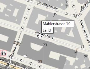
You can also see the housenumbers as a popup now (if in OSM):

New Easy Layout - I spent nearly one week trying out and working on this new layout. It is now based on wide layout, and really makes an easy and simple to understand map layout. (tracks are red, pathes if not paved are brown). Also I made the forests greener - so it's aimed at leaving the trails and venture through unknown terrain. So for everyone who thinks the openmtbmap layout is too complicated, give this a shot (it's been implemented since 2 weeks).
MTB Routes are now brownish colour - I do think mtb routes are an important part of any mtb map, but to be blunt - in most places mtb routes are nothing but boring if you are on a full-suspension bike. Therefore they are now not sticking out of the map layout so much anymore, and make the map more pleasing too look at (less distraction).
I hid the links to the outdated and old CCBSA2.0 maps a bit on the website. I noticed quite a few people unintentionally got the old maps, not knowing what CCBYSA and odbl is about. I will still leave them online for a couple of month, but I think there is nowhere in the world, where the old maps still have much reason to be preferred. (especially on the Europe map this caused some confusion).
Here's the rest of the main changes:
reinclude amenity=parking
mtbroutes of low importance, not anymore visible in resolution 19. All mtbroutes shown one zoom level later.
Change text label sizes to invisble for service roads, unclassifieds, all tracks, roundabouts and steps. Also remove 20m lines text label. ( I do hope the broken firmwares due to why I did this once are not in use anymore)
Add natural=... grassland, reef, desert and cape. Remove natural=* (unknown).
and lots of other very minor changes.
Oh and if you like the Openmtbmaps - don't forget to donate after your next map download. Thanks if you already did so!


Leave a Reply
You must be logged in to post a comment.