Map Updates overdue for 3 Weeks
First of all a big big sorry - the last map updates are overdue for 3 weeks. This is the first time ever that there have been no map updates for such a long long time! I'm right now trying quite hard to learn Chinese - and so in May I spent 4 weeks in China. It was a nice trip - however 2 days after arriving the map compilation server (it's completely independent of the website server) got hacked and encrypted. The attackers must have used one of the several Windows RDP bugs (a brute force attack on the password seems highly unlikely). This is the first time one of my servers actually got hacked in 10 years. Now had I been in anywhere else in the world (but China, Cuba or North Korea) fixing this and setting up the server from scratch would have been pretty easy. Being in China and needing to pass the notoriously slow Chinese great firewall - I could not fix it.
There has been no breach of any user data (the data is on another server). Also there were no compromitted maps or anything harmful uploaded (just the whole server got encrypted - actually breaking the upload service for the maps).
I've returned on Friday afternoon and since then spent many many hours securing/fixing the map compilation server (as Windows RDP seems to be right now under pretty heavy attacks I hope this won't happen again, but Windows servers are nowhere near as bug free as Linux based servers sadly). When restoring the server this time I've made sure to upload also program configurations into my SVN repository - so should I need to setup the server again - it will be only a matter of 2-3 hours, not 30-40 hours fixing it. As of today, Sunday the map server is underway rendering new maps - but a full rendering of the maps takes 2.5 days, plus then 1.5 more days for the European continent maps - so updates are coming in soon!
(The website server is running Ubuntu Linux 18.04 LTS - and is heavily secured - I'm paramount here about security)
10 Years OpenMTBMap.org - Happy Birthday
7. April 2019 was the 10 year Birthday of OpenMTBMap.org! OpenMTBMap.org, On 6 April 2019 I finally decided to offer the OpenMTBMaps not only as a script to be downloaded from the OSM wiki for people to render themselves - but offer the maps (it was first only Austria, Switzerland and Germany (well Germany 2 days later as traffic was too high) for download to everyone via the newly created website. Basically on the 6. April I registered the domain, downloaded wordpress - and installed it to a shared server.
Working late into the night of the 7. April the website went online around 4AM - and I mentioned it on the OSM wiki. When I woke up after a couple of hours - it had spread so fast that a couple of hours later the webhost (yes - unlimited everything shared hosting is always a lie if cheap!) took it offline. A couple of days later on a donated root server it was back up and stayed online with over 99.90% uptime since.
Within a couple of weeks I've added maps of basically all of Europe.
While the first 2 years everything on OpenMTBMap.org was completely free - including countless hours spent on supporting people (I added a donation button after about 1 year) - it soon took over way too much work (especially answering emails/comments) so that I had to turn it into a freemium project and register my business as a company (self employed/selbständig). However everything, except support, that was free, stayed free. While new things got into the premium section. The pricing of 20€ for the first year has not been increased since 2011. For more years/subsequent years the prices have been stable since 2013. Actually those people who have bugged me with the most stupid questions while everything was free - luckily mostly never payed. Yes from time to time I still have to answer questions from people clearly not reading the tutorials at all or confusing something major, trying to stay as friendly as possible - but this has been much less common compared to the time everything was free (well the difference is that back then I would at some point not answer anymore - now for paying customers I do my utmost to answer and answer no matter how long it takes to explain. Usually if someone describes his problem well - a single email/comment is enough anyhow.).
About a year later - in April 2014 VeloMap.org was added as the maps needed to be better specialised for mtbiking vs cycling.
The domain name Open MTB Map.org was/is based on Open Street Map.org (OSM)- I just exchanged Street with MTB. I've since then actually got hold of some much better domain names - like mtbmap.com or outdoormaps.com. I'm often thinking of rebranding the maps - because to people not firm with OSM the domain name is not intuitive. However so far I've stayed with it.
So also a big thank you to all the supporters/donators/members of OpenMTBMap.org and VeloMap.org over the last 10 years! Without you I could not have continued to put so much work into the maps and fighting Garmins ever changing firmwares and software for the better.
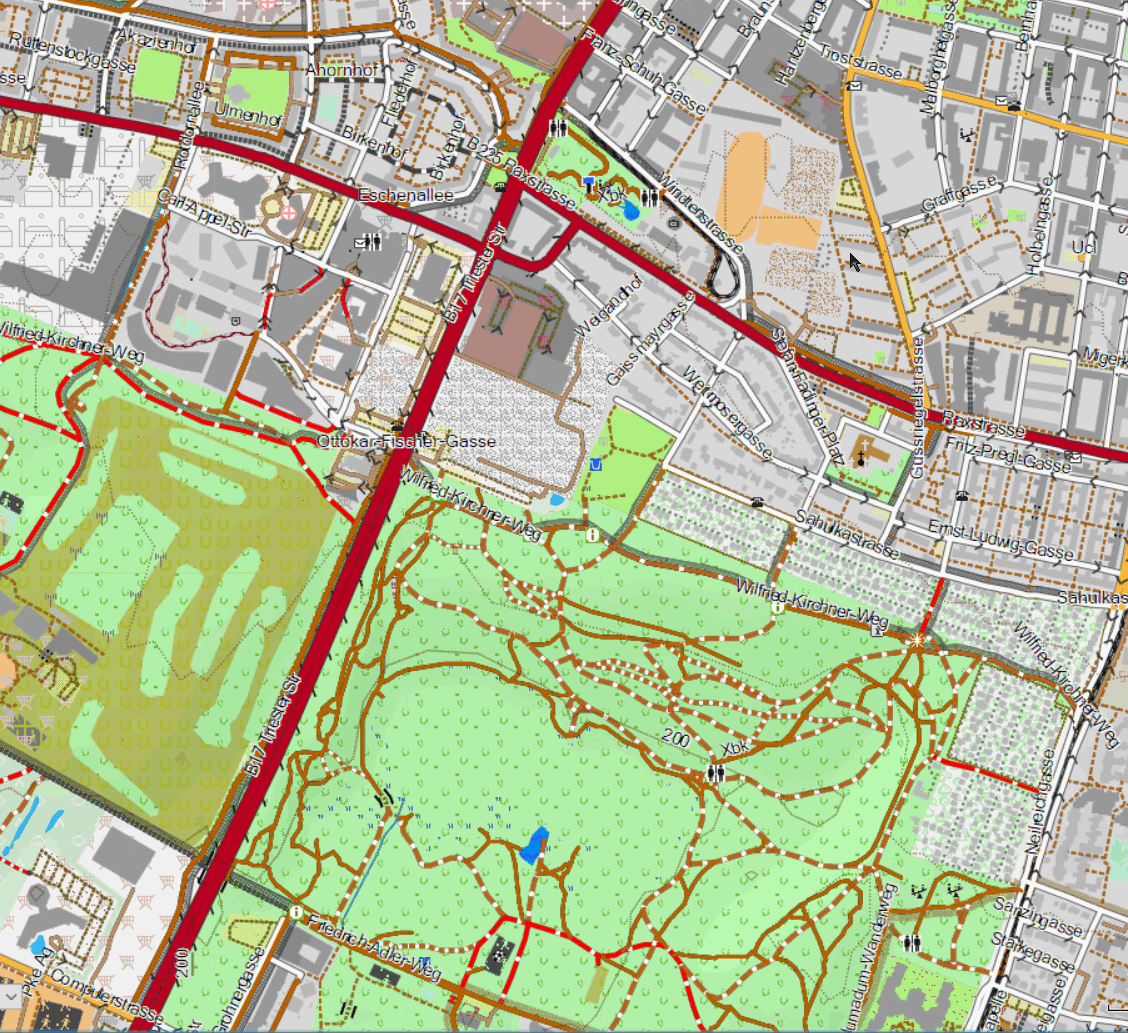
Screenshot of the OpenMTBMap in Vienna, Wienerberg - from the first map uploaded to OpenMTBMap.org:

vs current look of the same area (traditional/desktop layout - OpenMTBMap Austria 09.05.2019 - sadly the lake is currently not correctly entered in Openstreetmap.org as multipolygon):
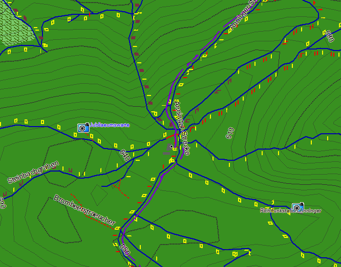
And a second example - Anninger Mödling:
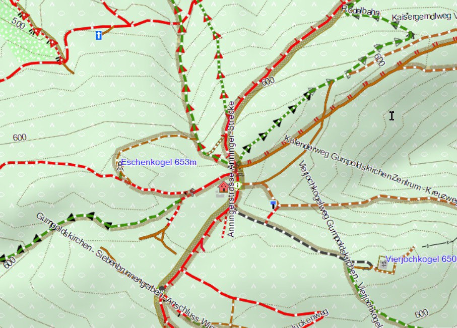
vs the current Screenshot (what a difference!):


Recent Comments