11. May Map Updates – New Overview Map

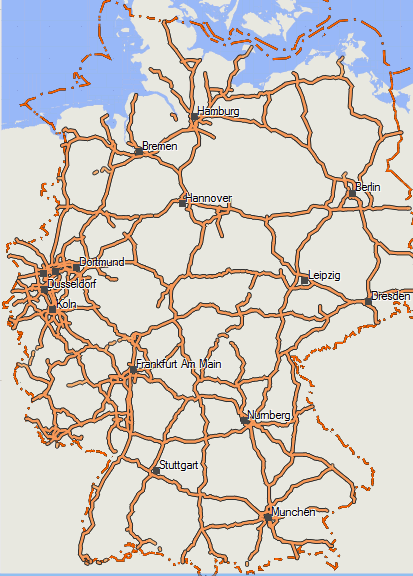
Well finally after many years of empty overview maps, since a few weeks (as written in my last posts) mkgmap was able to write simple overviewmaps. So much faster zooming/panning when zoomed out fast in Mapsource, Basecamp, QLandkarteGT. From todays map update onwards, the overview map now has several layers. This makes the orientation when zoomed out far, still a lot better.


Therefore I also update the Europe map again, because on large area maps, this is even more important. However not only is it faster now on the desktop - but also on the GPS the basemap will become visible earlier, making zooming out work much faster (before I always had to compromise between speed on GPS, vs speed on Desktop, not anymore). Therefore however again I had to add some types to the .typ-file (0x11f04, 0x11f05, 0x10f0a).


Besides the work on the overview map, I will start to work on a worldwide basemap. The problem is that currently some Garmin GPS come with a routeable basemap, in some cases this destructs the routing of detailed maps, like openmtbmaps and velomaps. I will try to create a good basemap, that can go in combination with velomaps/openmtbmap showing the most important map features there are (rivers, lakes, sea, huge cities, borders, motorways, maybe some major railways...).


Fixed bug that Ireland and Northern Ireland was not updated over the last 3 weeks.

Further changes:

add bridge=culvert and bridge=boardwalk.

fix some more bugs related to autorouting in velomap/openmtbmap

and some more little bugfixes...


the new overview map at 150km zoomed out, Detail level High. Very fast...

Overview Map Germany, 150km, Zoomlevel High


Some further work on the overview map – and Peru as a new country

Well lets make the newsletter a bit shorter this time but keep it more uptodate. First of all, if you downloaded Fridays maps, there was a bug in the overviewmap content to be seen at all resolutions in Basecamp.  (the bug didn't affect the map view on the GPS devices, nor in Mapsource or Qlandkarte GT). This got fixed if you downloaded the maps on Saturday or later. So if you wonder about straight motorways appearing twice - there a gone again now. However a nice feature - of the background changing colour slightly depending on the resolution is gone now. Also the typfiles needed to be changed again (0x4b is now again the background).


For Mac OSx downloads, I renamed the downloads from COUNTRY.gmap.7z to COUNTRY_macosx.7z. This is only the name of the packed download. However if you did make a mistake and extracted the content not using "extract here" but "extract to "COUNTRY.gmap" the problem of macosx making automatically a kinda broken gmap installation package out of it is solved now. So if you unpack now to "COUNTRY_macosx" - then it will be recognized as a standard folder, which you can access normally and not recognized as a package.


Since Geofabrik is offering a Peru country extract, Peru is available for download too now - so the most touristic countries in South America now all got their own country extract - less need for the full South America continent map download.


Also in my last newsletter, I forgot to mention that the full Asia continent contourlines are updated now, to a good quality standard. They are still too large to be integrated into the maps, but if you really need them, and know how to use them, they are good quality too now. Also the Himalaya contours extract is updated, covering a larger region than before - and slightly better quality.


Next Thursday I fly for 5 weeks to Santiago de Chile. Twould be nice to go mountainbiking there (though I will need to rent a mountainbike), so if anyone openmtbmap user lives in or aroung Santiago, I'ld be happy to hear from you. I won't go there for holidays though, I'll be working from a co-working space, and try to push Openstreetmap / Openmtbmap and bicycle/mtb information there a bit.


Famous Machu Picchu in Peru  - still some mapping to be done: