New Contourlines for all Maps – and again – Please Stick to Basecamp 4.6.x

1. Yesterdays/Day before Yesterdays map update of the Europe Map has new contourlines - so especially all OSx users - please do not reuse the old contourlines. For Windows the installer throws an error message anyhow.

It took me a lot of time to iron out bugs in the contourline data, convert it correctly to the needed input formats - fill voids and put it together. The Europe map is now the first to be fully based on Sonnys LIDAR data where available (Italy is new), elsewhere the still pretty excellent ALOS World 30m data - and from 60° northwards voidfilled viewfinderpanoramas 3" data. Yes except for the Alps the Viewfinderpanoramas 3" data used to be the common source for all my contourline maps - it's IMHO crazy how much better the ALOS - and of course LIDAR data is in mountaineous regions. LIDAR data is from laser scanning - of course that will be the best possible to attain, however the ALOS data (downsampled from Alos World 5m data to 30m) is where it's not voidfilled by SRTM1v3.0 really astonishingly good in my eyes. Often flatter forest areas are put 5-10m too high (but SRTM and viewfinderpanoramas also have that problem - if a little less) - but especially in rougher areas the accuracy is pretty good.

I've now also put 10m contourlines instead of 20m interval to all European countries that have no summit over 500m altitude (and to some Germany Bundesländer Maps). Else it's 20m.

This weeks map update will be using the new contourlines for most European countries, and some worldwide countries - however only for maps where the contourlines are not a separate download. Next week map update will then have the new better contourlines for all countries. 

Also of course again all contourline maps come with altitude shading and for those countries like Europe continent map where partly contourlines where missing - this should be fixed with the new contourlines.


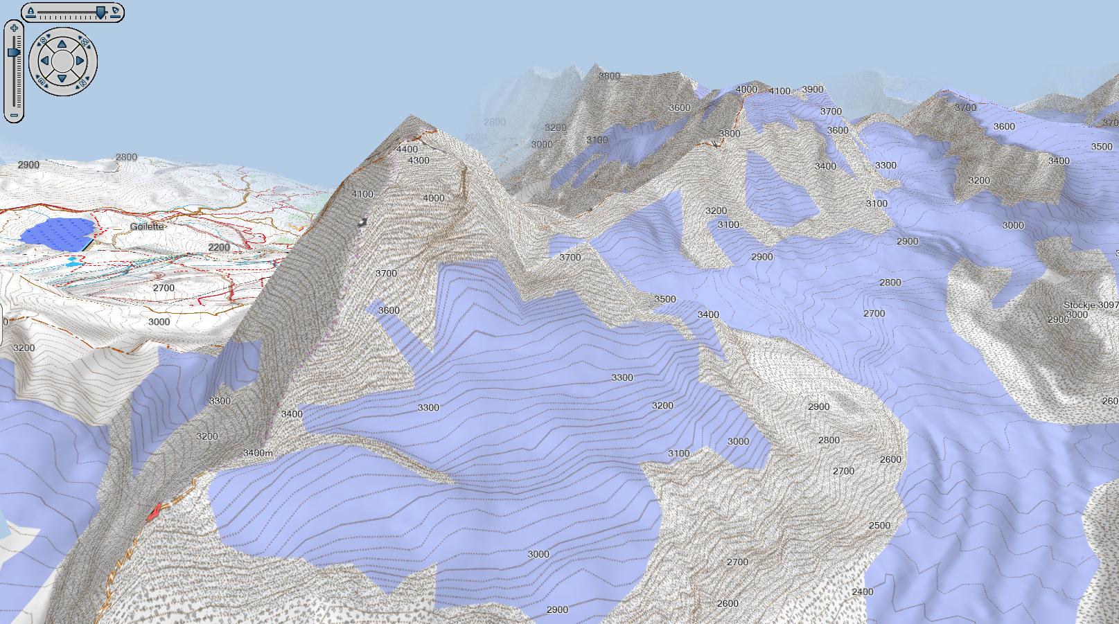
See below for the Matterhorn - the Matterhorn is pretty much data rubbish in most elevation models - due to it's sticky pointyness, usual cloud cover and glaciers. Thanks to LIDAR data it's really pretty exact (compare that to SRTM1 rubbish in Google earth for fun).

Matterhorn 3D View in Basecamp


2. Again to stress on Basecamp 4.7.0 - Please do not use it neither on OSx, nor on Windows. It is prone to crashes  - and while on Windows MapInstall 4.2.0 which comes with it - will not send maps on Windows, and often crash while sending larger maps on OSx.

On Windows make sure to run both Uninstall and Installation with Administrator rights - and if you have Problems - Uninstall again - and delete all garmin Folders in Program Files / Program Files X86 folders. Your userdata is safe and not affected as that is in your Userprofile / Appdata folder (no  need to delete anything here).

On OSx I'm not quite sure how to check correct full uninstallation - but it should be similar. 

See also: https://openmtbmap.org/updates/do-not-update-to-basecamp-v-4-7-0/


Do NOT Update to Basecamp v 4.7.0!

Sorry this is just a quick message - but because it's kinda important and may cause a lot of confusion - I send out this short newsletter.

Update - see here for up to date instructions how to downgrade: https://www.velomap.org/tutorials/basecamp-4-7-0/

 Garmin released a new version of Basecamp - 4.7.0 - in order to remove many features that were not in accordance with the GDPR regulation. Actually it's not that 4.6.2 is wrong here - it's that there were a few web services - that Garmin switched off - and those were interlinked into 4.6.2 - so that actually in 4.6.2 some functionality is not working anymore - I could on a quick check however not discover any actual difference otherwise in relation to the GDPR regulations - so 4.6.2 is no different in this regard to 4.7.0 - well and new privacy page/EULA of course).

Now the problem is - Basecamp 4.7.0 also ships an updated version of Garmin MapInstall - and that version is broken in so far that it does not send any maps in .img format anymore! This also applies to original garmin maps. I have some old Garmin Topo Austria and Garmin City Navigator map - that cannot be sent anymore. Also any of the garmin demo maps converted into .img format from gmapsupp.img do not transfer anymore.


If you are a Windows user and upgraded to 4.7.0 you have 3 choices:

a) Downgrade to Basecamp v 4.6.2: it can be found here: http://www.gawisp.com/perry/mapsource/

ATTENTION - you need to first deinstall Basecamp, then Install Basecamp 4.6.2. If you simply install 4.6.2 without deinstalling 4.7.0 Mapinstall is not correctly downgraded.

b) download the OSx (Mac) version of all openmtbmaps/velomaps in .gmap format. You can install them by placing them into the C:\ProgramData\GARMIN\maps\mtbCOUNTRY.gmap respectively C:\ProgramData\GARMIN\maps\veloCOUNTRY.gmap and better read the OSx tutorial too: https://openmtbmap.org/tutorials/install-maps-mac-osx/ respectively for Velomap users here: https://www.velomap.org/tutorials/install-maps-mac-osx/

c) do not send any .img format maps until Garmin releases a new version without this bug.

d) Use the plain old Garmin Mapsource for sending maps. Yes it still works if you know what to do - just note that it does not check any maps installed - so do not send maps twice. Also it cannot like MapInstall overcome the 4GB limit by splitting up maps that you are sending. Else of course it cannot correctly show the contourlines - but sending maps will work.

Actually right now only a part of the overview map is sent - it would be nice if Garmin could send the overview maps in general too - as right now they are only used on Desktop. Would actually speed up the GPS devices a bit - especially if you have no activated Basemap on your device.


Besides this: I'm still working hard on improving the contourlines just another time, and fixing some bugs (e.g. in the Europe continent map right now in the north of Norway/Sweden some contourlines/DEM data is missing). Should not take long anymore. Expect a new release of the Europe map in the next 10 days (also worldwide all maps will come soon with even better DEM/contourlines).


Oh and of course I also updated my Privacy/Rules according to the GDPR rules now effective. Actually nothing changed except that I explained a bit better which data I gather (which was very easy to see/find out anyhow).

In effect I do not store (except temporary logs on my server) any data from users except the one I'm forced to store for invoice creation and making sure you can login to your account. (IP address, email, name, address) and yes I use google analytics in anonymized mode. Still due to great wisdom in actual IT knowledge of our chosen EU representatives and local governments the privacy rules have become long and tedious to read....

If I could I would not store addresses at all - but well VATMOSS EU regulations force me to do so. So nearly all of the personal data I gather, I gather only because just of another super stupid EU regulation.